|
|
| INSTRUMENT PROCEDURES HANDBOOK |
|
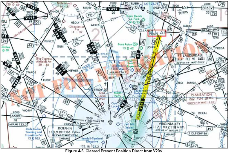
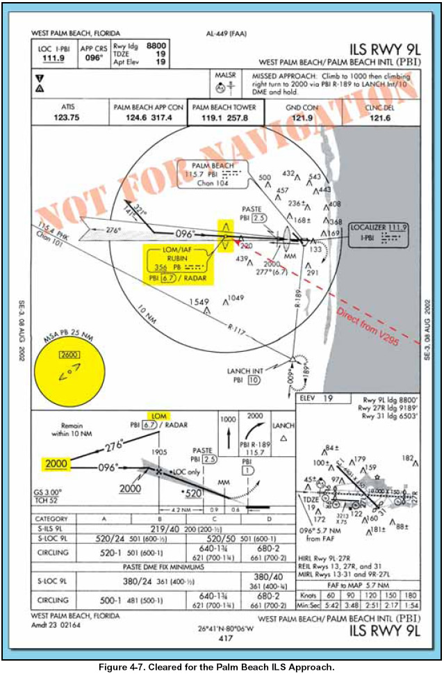
APPROACH CLEARANCE The approach clearance provides guidance to a position from where you can execute the approach, and it also clears you to fly that approach. If only one approach procedure exists, or if ATC authorizes you to execute the approach procedure of your choice, the clearance may be worded as simply as “… cleared for approach.” If ATC wants to restrict you to a specific approach, the controller names the approach in the clearance—for example, “…cleared ILS Runway 35 Right approach.” When the landing will be made on a runway that is not aligned with the approach being flown, the controller may issue a circling approach clearance, such as “…cleared for VOR Runway 17 approach, circle to land Runway 23.” When cleared for an approach prior to reaching a holding fix, ATC expects the pilot to continue to the holding fix, along the feeder route associated with the fix, and then to the IAF. If a feeder route to an IAF begins at a fix located along the route of flight prior to reaching the holding fix, and clearance for an approach is issued, the pilot should commence the approach via the published feeder route. The pilot is expected to commence the approach in a similar manner at the IAF, if the IAF is located along the route to the holding fix. ATC also may clear an aircraft directly to the IAF by using language such as “direct” or “proceed direct.” Controllers normally identify an approach by its published name, even if some component of the approach aid (such as the glide slope of an ILS) is inoperative or unreliable. The controller uses the name of the approach as published but advises the aircraft when issuing the approach clearance that the component is unusable. PRESENT POSITION DIRECT In addition to using National Aeronautical Charting Office (NACO) high and low altitude en route charts as resources for your arrival, NACO area charts can be helpful as a planning aid for situational awareness. Many pilots find the area chart helpful in locating a depicted fix after ATC clears them to proceed to a fix and hold, especially at unfamiliar airports. Looking at Figures 4-6, and 4-7 on page 4-8, assume you are V295 northbound en route to Palm Beach International Airport. You are en route on the airway when the controller clears you present position direct to the outer marker compass locator and for the instrument landing system (ILS) approach. There is no transition authorized or charted between your present position and the approach facility. There is no minimum altitude published for the route you are about to travel.
In Figure 4-6, you are just north of HEATT Intersection at 5,000 feet when the approach controller states, “Citation 9724J, 2 miles from HEATT, cleared present position direct RUBIN, cleared for the Palm Beach ILS Runway 9L Approach, contact Palm Beach Tower on 119.1 established inbound.” With no minimum altitude published from that point to the RUBIN beacon, you should maintain the last assigned altitude until you reach the IAF (that’s the fix, not the facility). Then, in Figure 4-7 on page 4-8, after passing the beacon outbound, commence your descent to 2,000 feet for the course reversal.
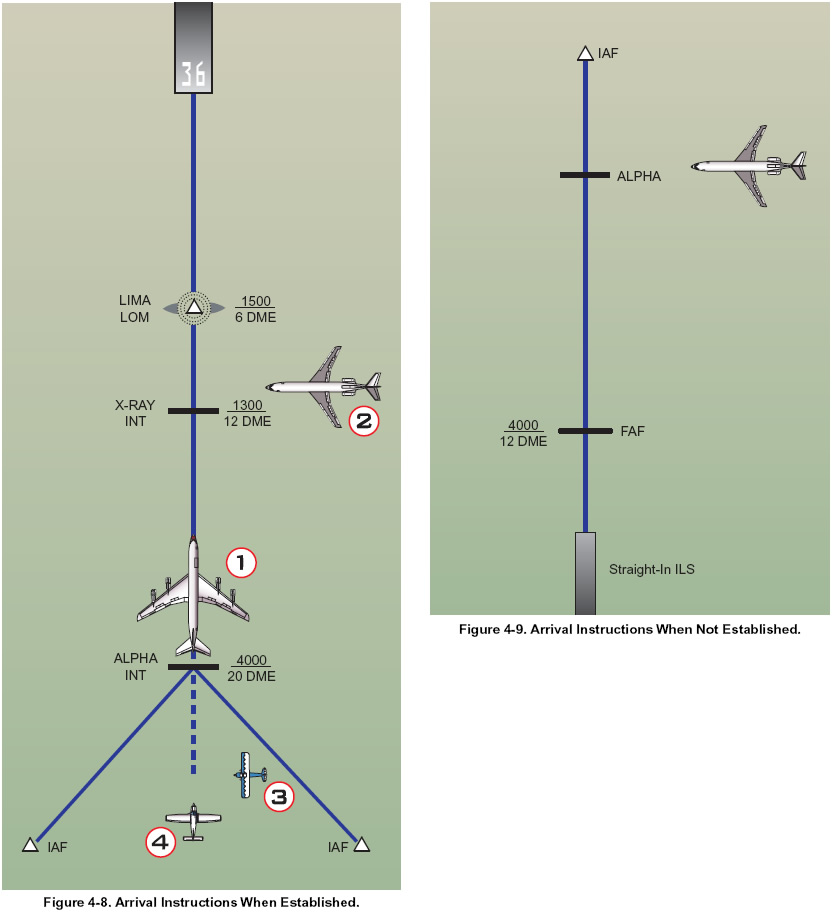
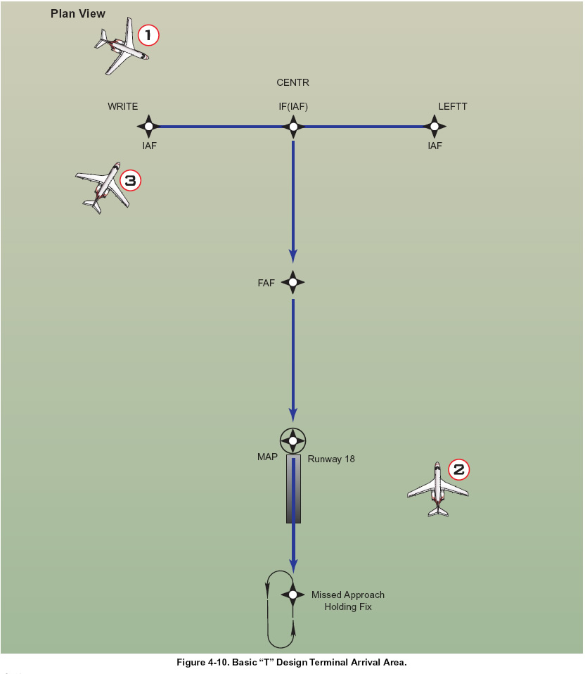
The ILS procedure relies heavily on the controller’s recognition of the restriction upon you to maintain your last assigned altitude until “established” on a published segment of the approach. Refer to Appendix B, “Staying Within Protected Airspace,” for a comprehensive discussion of “established.” Prior to issuing a clearance for the approach, the controller usually assigns the pilot an altitude compatible with glide slope intercept. RADAR VECTORS TO FINAL APPROACH COURSE Arriving aircraft usually are vectored to intercept the final approach course, except with vectors for a visual approach, at least 2 NM outside the approach gate unless one of the following exists: 1. When the reported ceiling is at least 500 feet above the minimum vectoring altitude or minimum IFR altitude and the visibility is at least 3 NM (report may be a pilot report if no weather is reported for the airport), aircraft may be vectored to intercept the final approach course closer than 2 NM outside the approach gate but no closer than the approach gate. 2. If specifically requested by a pilot, ATC may vector aircraft to intercept the final approach course inside the approach gate but no closer than the FAF. For a precision approach, aircraft are vectored at an altitude that is not above the glide slope/glidepath or below the minimum glide slope intercept altitude specified on the approach procedure chart. For a nonprecision approach, aircraft are vectored at an altitude that allows descent in accordance with the published procedure. When a vector will take the aircraft across the final approach course, pilots are informed by ATC and the reason for the action is stated. In the event that ATC is not able to inform the aircraft, the pilot is not expected to turn inbound on the final approach course unless an approach clearance has been issued. An example of ATC phraseology in this case is, “…expect vectors across final for spacing.” The following ATC arrival instructions are issued to an IFR aircraft before it reaches the approach gate: 1. Position relative to a fix on the final approach course. If none is portrayed on the controller’s radar display or if none is prescribed in the instrument approach procedure, ATC issues position information relative to the airport or relative to the navigation aid that provides final approach guidance. 2. Vector to intercept the final approach course if required. 3. Approach clearance except when conducting a radar approach. ATC issues the approach clearance only after the aircraft is established on a segment of a published route or instrument approach procedure, or in the following examples as depicted in Figure 4-8 on page 4-9. Aircraft 1 was vectored to the final approach course but clearance was withheld. It is now at 4,000 feet and established on a segment of the instrument approach procedure. “Seven miles from X-RAY. Cleared ILS runway three six approach.” Aircraft 2 is being vectored to a published segment of the final approach course, 4 NM from LIMA at 2,000 feet. The minimum vectoring altitude for this area is 2,000 feet. “Four miles from LIMA. Turn right heading three four zero. Maintain two thousand until established on the localizer. Cleared ILS runway three six approach.” There are many times when it is desirable to position an aircraft onto the final approach course prior to a published, charted segment of an instrument approach procedure (IAP). Sometimes IAPs have no initial segment and require vectors. “RADAR REQUIRED” will be charted in the planview. Sometimes a route will intersect an extended final approach course making a long intercept desirable. When ATC issues a vector or clearance to the final approach course beyond the published segment, controllers assign an altitude to maintain until the aircraft is established on a segment of a published route or IAP. This ensures that both the pilot and controller know precisely what altitude is to be flown and precisely where descent to appropriate minimum altitudes or step-down altitudes can begin. Most aircraft are vectored onto a localizer or final approach course between an intermediate fix and the approach gate. These aircraft normally are told to maintain an altitude until established on a segment of the approach. When an aircraft is assigned a route that will establish the aircraft on a published segment of an approach, the controller must issue an altitude to maintain until the aircraft is established on a published segment of the approach. Aircraft 4 is established on the final approach course beyond the approach segments, 8 NM from Alpha at 6,000 feet. The minimum vectoring altitude for this area is 4,000 feet. “Eight miles from Alpha. Cross Alpha at or above four thousand. Cleared ILS runway three six approach.” If an aircraft is not established on a segment of a published approach and is not conducting a radar approach, ATC will assign an altitude to maintain until the aircraft is established on a segment of a published route or instrument approach procedure, as depicted in Figure 4-9.
The aircraft is being vectored to a published segment of the ILS final approach course, 3 NM from Alpha at 4,000 feet. The minimum vectoring altitude for this area is 4,000 feet. “Three miles from Alpha. Turn left heading two one zero. Maintain four thousand until established on the localizer. Cleared ILS runway one eight approach.” The ATC assigned altitude ensures IFR obstruction clearance from the point at which the approach clearance is issued until established on a segment of a published route or instrument approach procedure. ATC tries to make frequency changes prior to passing the FAF, although when radar is used to establish the FAF, ATC informs the pilot to contact the tower on the local control frequency after being advised that the aircraft is over the fix. For example, “Three miles from final approach fix. Turn left heading zero one zero. Maintain two thousand until established on the localizer. Cleared ILS runway three six approach. I will advise when over the fix.” “Over final approach fix. Contact tower one one eight point one.” Where a terminal arrival area (TAA) has been established to support RNAV approaches, as depicted in Figure 4-10, ATC informs the aircraft of its position relative to the appropriate IAF and issues the approach clearance, as shown in the following examples:
Aircraft 1 is in the straight-in area of the TAA. “Seven miles from CENTR, Cleared RNAV Runway One Eight Approach.’’ Aircraft 2 is in the left base area of the TAA. “Fifteen miles from LEFTT, Cleared RNAV Runway One Eight Approach.’’ Aircraft 3 is in the right base area of the TAA. “Four miles from WRITE, Cleared RNAV Runway One Eight Approach.” IFR en route descent procedures should include a review of minimum, maximum, mandatory, and recommended altitudes that normally precede the fix or NAVAID facility to which they apply. The initial descent gradient for a low altitude instrument approach procedure does not exceed 500 feet per NM (approximately 5 degrees), and for a high altitude approach, the maximum allowable initial gradient is 1,000 feet per NM (approximately 10 degrees). Remember during arrivals, when cleared for an instrument approach, maintain the last assigned altitude until you are established on a published segment of the approach, or on a segment of a published route. If no altitude is assigned with the approach clearance and you are already on a published segment, you can descend to its minimum altitude.
|