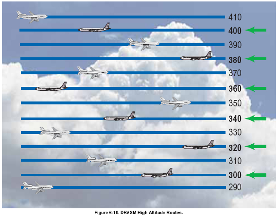
REDUCING VERTICAL SEPARATION
Current vertical separation minima (2,000 feet) were
created more than 40 years ago when altimeters were
not very accurate above FL 290. With better flight and
navigation instruments, vertical separation has been
safely reduced to 1,000 feet in most parts of the world,
except Africa and China.
RVSM airspace has already been implemented over the
Atlantic and Pacific Oceans, South China Sea, Australia,
Europe, the Middle East and Asia south of the
Himalayas. Domestic RVSM (DRVSM) in the United
States was implemented in January 2005 when FL 300,
320, 340, 360, 380, and 400 were added to the existing
structure. To fly at any of the flight levels from FL 290
to FL 410, aircraft and operator must be RVSMapproved.
[Figure 6-10]
REDUCING HORIZONTAL SEPARATION
The current oceanic air traffic control system uses filed
flight plans and position reports to track an aircraft’s
progress and ensure separation. Pilots send position
reports by high frequency (HF) radio through a private
radio service that then relays the messages to the air traffic
control system. Position reports are made at intervals
of approximately one hour. HF radio communication is
subject to interference and disruption. Further delay is
added as radio operators relay messages between pilots
and controllers. These deficiencies in communications
and surveillance have necessitated larger horizontal separation
minimums when flying over the ocean out of
radar range.
As a result of improved navigational capabilities made
possible by technologies such as GPS and CPDLC, both
lateral and longitudinal oceanic horizontal separation
standards are being reduced. Oceanic lateral separation
standards were reduced from 100 to 50 NM in the
Northern and Central Pacific regions in 1998 and in the
Central East Pacific in 2000. The FAA plans to extend
the 50 NM separation standard to the South Pacific.
Because flight times along the South Pacific routes often
exceed 15 hours, the fuel and time savings resulting
from more airplanes flying closer to the ideal wind route
in this region are expected to be substantial. Separation
standards of 30 NM are already undergoing operational
trials in parts of South Pacific airspace for properly
authorized airplanes and operators.
DIRECT ROUTING
Based on preliminary evaluations, FAA research has evidenced
tremendous potential for the airlines to benefit
from expected routing initiatives. Specifically, direct
routing or “Free Flight” is the most promising for reducing
total flight time and distance as well as minimizing
congestion on heavily traveled airways. Traditionally,
pilots fly fixed routes that often are less direct due to
their dependence on ground-based NAVAIDs. Through
Free Flight, the FAA hopes to increase the capacity, efficiency,
and safety of the NAS to meet growing demand
as well as enhance the controller’s productivity. The aviation
industry, particularly the airlines, is seeking to
shorten flight times and reduce fuel consumption.
According to the FAA’s preliminary estimates, the benefits
to the flying public and the aviation industry could
reach into the billions of dollars once the program is
fully operational.
Free Flight Phase 1 began in October 1998 and launched
five software tools over the next four years. These were
Collaborative Decision Making (CDM), the User
Request Evaluation Tool (URET), and the previously
discussed SMA, TMA, and pFAST.
CDM allows airspace users and the FAA to share information,
enabling the best use of available resources. It
provides detailed, real-time information about weather,
delays, cancellations, and equipment to airlines and
major FAA air traffic control facilities. This shared data
helps to manage the airspace system more efficiently,
thereby reducing delays.
CDM consists of three components. The first component
allows airlines and the FAA’s System Command
Center in Herndon, Virginia, to share the latest information
on schedules, airport demand, and capacity at times
(usually during bad weather) when airport capacity is
reduced. This shared information is critical to getting
the maximum number of takeoffs and landings at airports.
The second component creates and assesses
possible rerouting around bad weather. This tool
enables the Command Center and busy major ATC
facilities to share real-time information on high-altitude
traffic flows with airline operations centers, thus
developing the most efficient ways to avoid bad
weather. The third component provides data on the
operational status of the national airspace system.
Examples include runway visibility at major airports
and the current availability of Special Use Airspace.
URET allows controllers to plot changes in the projected
flight paths of specific airplanes to see if they will get
too close to other aircraft within the next 20 minutes.
URET means that controllers can safely and quickly
respond to pilots’ requests for changes in altitude or
direction, which leads to smoother, safer flights and
more direct routings. During trials in the Memphis and Indianapolis en route centers, the use of more direct
routes made possible by URET was found to save airlines
about $1.5 million per month. |
