 |
|
| INSTRUMENT PROCEDURES HANDBOOK |
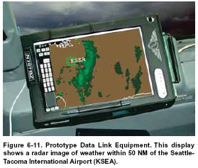
ACCOMMODATING USER PREFERRED ROUTING Free Flight Phase 2 builds on the successes of Free Flight Phase 1 to improve safety and efficiency within the NAS. Implementation of Phase 2 will include the expansion of Phase 1 elements to additional FAA facilities. This program will deploy a number of additional capabilities, such as CDM with collaborative routing coordination tool (CRCT) enhancements and CPDLC. The National Airspace System status information (NASSI) tool is the most recent CDM element to be introduced. NASSI enables the real-time sharing of a wide variety of information about the operational status of the NAS. Much of this information has previously been unavailable to most airspace users. NASSI currently includes information on maintenance status and runway visual range at over 30 airports. The CRCT is a set of automation capabilities that can evaluate the impact of traffic flow management rerouting strategies. The major focus of this tool is management of en route congestion. IMPROVING ACCESS TO SPECIAL USE AIRSPACE Special use airspace (SUA) includes prohibited, restricted, warning, and alert areas, as well as military operations areas (MOAs), controlled firing areas, and national security areas. The FAA and the Department of Defense are working together to make maximum use of SUA by opening these areas to civilian traffic when they are not being used by the military. The military airspace management system (MAMS) keeps an extensive database of information on the historical use of SUA, as well as schedules describing when each area is expected to be active. MAMS transmits this data to the special use airspace management system (SAMS), an FAA program that provides current and scheduled status information on SUA to civilian users. This information is available at the following link http://sua.faa.gov/. The two systems work together to ensure that the FAA and system users have current information on a daily basis. A prototype system called SUA in-flight service enhancement (SUA/ISE) provides graphic, near-realtime depictions of SUA to automated flight service station (AFSS) specialists who can use the information to help pilots during flight planning as well as during flight. Pronounced “Suzy,” this tool can display individual aircraft on visual flight rule (VFR) flight plans (with data blocks), plot routes of flight, identify active SUA and display weather radar echoes. Using information from the enhanced traffic management system, AFSS specialists will see this information on a combined graphic display. This data may also be transmitted and shown on cockpit displays in general and commercial aviation aircraft. The central altitude reservation function (CARF) coordinates military, war plans, and national security use of the NAS. While SAMS handles the schedule information regarding fixed or charted SUA, CARF handles unscheduled time and altitude reservations. Both subsystems deal with planning and tracking the military’s use of the NAS. The FAA and the U.S. Navy have been working together to allow civilian use of offshore warning areas. When adverse weather prevents the use of normal air routes along the eastern seaboard, congestion and delays can result as flights are diverted to the remaining airways. When offshore warning areas are not in use by the Navy, the airspace could be used to ease the demand on inland airways. To facilitate the use of this airspace, the FAA established waypoints in offshore airspace along four routes for conducting point-to-point navigation when the Navy has released that airspace to the FAA. The waypoints take advantage of RNAV capabilities and provide better demarcation of airspace boundaries, resulting in more flexible release of airspace in response to changing weather. These new offshore routes, which stretch from northern Florida to Maine, are an excellent example of how close coordination between military and civil authorities can maximize the utility of limited airspace. HANDLING EN ROUTE SEVERE WEATHER Interpreting written or spoken weather information is not difficult, nor is visualizing the relationship of the weather to the aircraft’s route, although verbal or textual descriptions of weather have inevitable limitations. Color graphics can show more detail and convey more information, but obtaining them in flight has been impractical, until recently. The graphical weather service (GWS) provides a nationwide precipitation mosaic, updated frequently, and transmitted to the aircraft and displayed in the cockpit. Whether the display is used to strategize navigation, to avoid weather en route, or for departures and approaches, consideration must always be given to the timeliness of the graphic update. Pilots can select any portion of the nationwide mosaic with range options of 25, 50, 100, and 200 NM. In addition to providing information on precipitation, this service can be expanded to include other graphical data. Some systems will place the detailed weather graphics directly on a moving map display, removing another step of interpretation and enabling pilots to see the weather in relation to their flight path. [Figure 6-11]
|
