HELICOPTER APPROACHES TO VFR HELIPORTS
Helicopter approaches to VFR heliports are normally
developed either as public procedures to a point-inspace
(PinS) that may serve more than one heliport or
as a Special procedure to a specific VFR heliport that
requires pilot training due to its unique characteristics.
These approaches can be developed using VOR or
ADF, but RNAV using GPS is the most common system
used today. In the future, RNAV using the wide
area augmentation system (WAAS) offers the most
advantages because it can provide lower approach minimums,
narrower route widths to support a network of
approaches, and may allow the heliport to be used as an
alternate. A majority of the special procedures to a specific
VFR heliport are developed in support of helicopter
emergency medical services (HEMS) operators and
have a “Proceed Visually” segment between the MAP
and the heliport. Public procedures are developed as a
PinS approach with a “Proceed VFR” segment between
the MAP and the landing area. These PinS “Proceed
VFR” procedures specify a course and distance from
the MAP to the available heliports in the area.
APPROACH TO A POINT-IN-SPACE
The note associated with these procedures is: “PROCEED
VFR FROM (NAMED MAP) OR CONDUCT
THE SPECIFIED MISSED APPROACH.” They may
be developed as a special or public procedure where
the MAP is located more than 2 SM from the landing
site, the turn from the final approach to the visual segment
is greater than 30 degrees, or the VFR segment
from the MAP to the landing site has obstructions that
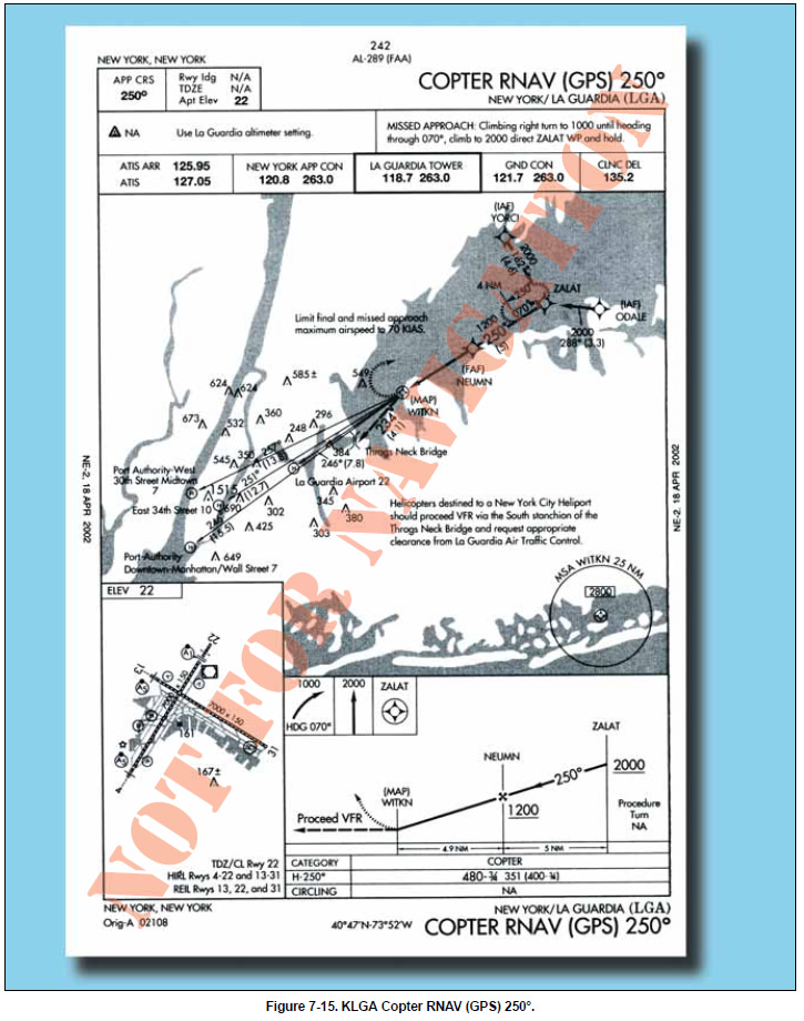
require pilot actions to avoid them. Figure 7-15 is an
example of a public PinS approach that allows the pilot
to fly to one of four heliports after reaching the MAP.
For Part 135 operations, pilots may not begin the instrument
approach unless the latest weather report indicates
that the weather conditions are at or above the
authorized IFR or VFR minimums as required by the
class of airspace, operating rule and/or OpsSpecs,
whichever is higher. Visual contact with the landing
site is not required; however, prior to the MAP, for
either Part 91 or 135 operators, the pilot must determine
if the flight visibility meets the basic VFR
minimums required by the class of airspace, operating
rule and/or OpsSpecs (whichever is higher). The
visibility is limited to no lower than that published
in the procedure until canceling IFR. If VFR minimums
do not exist, then the published missed
approach procedure must be executed. The pilot
must contact air traffic control upon reaching the
MAP, or as soon as practical after that, and advise
whether executing the missed approach or canceling
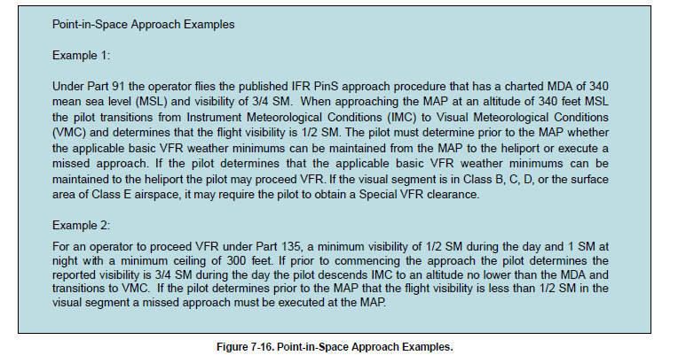
IFR and proceeding VFR. Figure 7-16 provides
examples of the procedures used during a PinS
approach for Part 91 and Part 135 operations.
To proceed VFR in uncontrolled airspace, Part 135
operators are required to have at least 1/2 SM visibility
and a 300-foot ceiling. Part 135 HEMS operators must
have at least 1 SM day or 2 SM night visibility and a
500-foot ceiling provided the heliport is located within
3 NM of the MAP. These minimums apply regardless
of whether the approach is located on the plains of
Oklahoma or in the Colorado mountains. However, for
heliports located farther than 3 NM from the heliport,
Part 135 HEMS operators are held to an even higher
standard and the minimums and lighting conditions
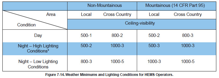
contained in Figure 7-14 apply to the entire route.
Mountainous terrain at night with low light conditions
requires a ceiling of 1,000 feet and either 3 SM or 5 SM
visibility depending on whether it has been determined
as part of the operator’s local flying area.
In Class B, C, D, and E surface area airspace, a SVFR
clearance may be obtained if SVFR minimums exist.
On your flight plan, give ATC a heads up about your
intentions by entering the following in the remarks section:
“Request SVFR clearance after the MAP.”
|
