|
|||||||||||||||||

|
|
|
|||
|
GE To Provide 3D
Airport Maps, High Resolution Terrain And Obstacle Aeronautical Data By Mike Mitchell |
||||
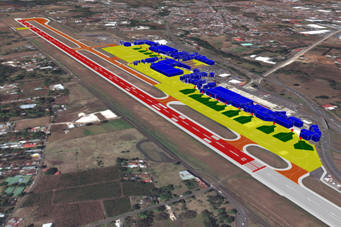 |
March 6, 2012 - GE Aviation announced its agreement with
GeoEye to provide the aviation industry with
ICAO-compliant terrain and obstacle aeronautical data
derived from GeoEye’s high resolution Earth imagery. GE
is showcasing this technology at ATC Global this week in
Amsterdam. As the first offering under this agreement, GE will provide ICAO Annex 15 Area-2 terrain and obstacle databases to support the development of new Performance-based Navigation (PBN) flight paths around the world.
This digital, highly detailed terrain and obstacle
mapping, collected by some of the world’s
highest-resolution commercial earth-imaging satellites,
will support the world's airport, airlines and aviation
authorities as they move to adopt PBN.
|
|||
|
“This
advanced aeronautical data, along with our Required Navigation
Performance (RNP) products, will accelerate the deployment of
RNP flight paths that will help meet the global challenge of
increasing efficiency in the world's air traffic management
system,” said Giovanni Spitale, general manager of GE’s PBN
Services. “It will allow the benefits of PBN to be achieved
earlier for the global air transportation community - saving
time, fuel, reducing emissions and noise while increasing hourly
operations frequency and maintaining safety.”
Additional
GE Aviation offerings under the agreement will support advanced
terrain and obstacle visualization, surface guidance through
airport mapping databases (AMDB), pilot simulator training and
flight operations quality assurance (FOQA) replay. Avionics
providers, airlines, and ANSPs will benefit from access to
accurate and current real world views of critical topography,
obstacles and airport details. GeoEye is a leading source of geospatial information and insight for decision makers and analysts, who need a clear understanding of our changing world to protect lives, manage risk and optimize resources. Each day, organizations in defense and intelligence, public safety, critical infrastructure, energy and online media rely on GeoEye's imagery, tools and expertise to support important missions around the globe. |
||||