Do’s and Don’ts For Aircraft Datalink Weather


NEWSROOM
 
 
  Bookmark and Share


Do’s and Don’ts For Aircraft Datalink Weather

By
Meredith Saini
 

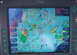
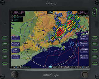
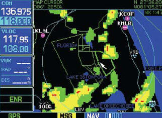
August 21, 2010 - Datalink is an industry term that many, including pilots, aviation journalists, and manufacturers, use to describe a wide range of equipment and services that all do one basic thing—get data into the cockpit so that the pilot can use it to make decisions.

The technology is relatively new and evolving so rapidly that we can’t even agree on how to spell it or define it, let alone use it. In the context of aviation weather information, datalink (or data link, if you prefer) refers to a service that uses a satellite antenna mounted on the aircraft, together with avionics in the cockpit, to receive, process, and display data such 
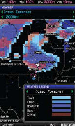
as NEXRAD radar, winds aloft, meteorological reports (METAR) and terminal aerodrome forecasts (TAF), freezing levels, and cloud coverage.  

This graphical and textual weather information can be displayed on a panel-mounted multifunction display (MFD) or moving-map GPS, as well as on many portable GPS devices. If you’ve ever used one of these tools to obtain weather information during a flight when severe weather was a factor, you’ve likely experienced the temptation to dodge around the nasty stuff using the animated color images.  

The main problem with using datalink weather products for tactical weather avoidance is that, much like network television, there is a built-in delay between reality and what you are seeing on the screen. For ATC radar, there can be a three- to five-minute delay from the time precipitation is sensed until it appears on the display. Bear in mind that this delay is in addition to the data “age” value shown on the MFD.

The main problem with using datalink for tactical weather avoidance is that there is a built-in delay between reality and what you see on the screen.


Develop a Strategy 

There I was in Hilton Head, South Carolina, on a blistering hot afternoon last summer, sitting in the left seat of a Cirrus SR22 with the left door open and my right ear glued to my cell phone. The Flight Service briefer on the other end of the line told me about multiple areas of developing severe thunderstorms along my route of flight back to Gaithersburg, Maryland, which would take me northeast along the Atlantic Coast past Myrtle Beach and Wilmington before turning north toward Norfolk, then northwest over Baltimore.


I could see the thunderstorms on the MFD, and I let the briefer know that I had the benefit of a datalink display. My strategy for avoiding convective weather during the flight involved booting up the avionics, downloading the datalink weather, and entering my flight plan route into the GPS before ever starting the engine or calling Flight Service. 

This enabled me to see the weather overlaid on the MFD map display while I was talking to the briefer and know immediately if the route I intended to fly would keep me clear of storms. If not, I could file a different route, start the engine, contact ground for an IFR clearance, and modify the flight plan, if needed, all within a few minutes.  

The NEXRAD picture gave me confidence that the first 150 miles or so of the trip would be clear of weather, with downloaded METARs showing scattered cumulus clouds between 4,000 and 8,000 feet. I determined from looking at the moving-map display (which was not yet moving since I was still on the ground) that the decision point for me to continue as filed or ask ATC for a reroute around the weather would likely arrive as I approached Myrtle Beach. With that strategy, I took off into the hazy sky and began 
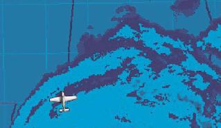
looking out the window for evidence of towering cumulonimbus clouds. 

There were plenty of them. Leveling off in cruise at 7,000 feet, I was above the scattered layer, but as I expected, by the time I reached Myrtle Beach the clouds had thickened and grown high around me. I was still clear of clouds and could see the tops of most of them, but it was obvious that if I continued northeast along the coast I would likely enter instrument conditions and lose visual contact with the storms. My goal was to remain in visual conditions for as long as possible, so that I could see the tops and use the MFD weather display to verify the storms’ intensity and relative movement. This would give me the information I would need to ask ATC for a different routing. 


Using Data to Modify the Plan 

Having used the datalink weather picture to confirm my decision to deviate around the storms ahead, I contacted Myrtle Beach Approach and asked for direct Fayetteville, which would put me squarely in between two clusters of thunderstorms, with about 40 miles of clearance on either side of my flight path, twice the recommended 20-mile lateral clearance. Based on my current ground speed I was confident that I could reach Fayetteville before the gap had a chance to close in because the storm track vector on the MFD weather page indicated that the cells were moving eastward relatively slowly.

I knew that, if by the time I got there it looked questionable to the north, I could just land at Fayetteville and wait it out. In preparation for a possible approach into Fayetteville, I pulled up the airport-facility information on the MFD and briefed the instrument approach plate electronically as well. Datalink weather is great on its own, but it’s even better when used in conjunction with a suite of other electronic information products.

Fortunately for me, the storms behaved as I expected they would and, by the time I reached Fayetteville, the route to Gaithersburg was already mostly clear. As I flew north past Richmond, I could see the sheared-off anvil-head tops of recently deceased thunderstorms to the west, backlit by the setting sun.

   
While every datalink weather display uses the same NWS data, variations exist in the way weather data are sliced, diced, and displayed. An Avidyne display showing datalink weather.  

Not only was it an incredibly beautiful sight, but the NEXRAD on the MFD showed no activity in that direction, which confirmed what I saw out the left window and gave me confidence to continue. About 45 minutes later, I landed in Gaithersburg, successfully completing a mission that would have been considerably more challenging without the availability of datalink weather. 

Interpreting the Picture  

While it’s true that every datalink weather display uses the same set of data produced by the National Weather Service (NWS), variations exist in the way weather data are sliced, diced, and displayed by the manufacturer—and these differences are not always intuitive. 

For example, on one MFD product, blue METAR flags over an airport represent VFR conditions whereas green flags represent marginal VFR conditions. When I first saw this depiction, I assumed that the green flags indicated the best weather, because the NWS uses green to represent VFR conditions in its online products.  

The moral of the story is that you need to learn each manufacturer’s color and symbology conventions, but it is generally the case that greens and cool colors represent non-threatening weather, while reds and warm colors represent weather that pilots should avoid.  

Other datalink weather graphics that are available on many MFD brands include cloud cover and cloud tops, winds-aloft forecasts, freezing levels, and lightning strikes. The latter can be used in conjunction with a separate onboard lightning strike detector to determine the relative position and intensity of convective activity. Terminal and area forecasts may also be available in a raw text format. 

Strategic, Not Tactical 

Pilots must understand the limitations of any datalink weather product before using it to make strategic in-flight decisions. For example, in addition to the inherent processing delay, the collection and delivery of NEXRAD data from ground stations can be affected by interference from buildings or terrain. 

Most datalink weather displays will provide some indication of the age of the data. This is especially important when using a textual METAR to determine whether a visual or an instrument approach will be required or to even make an early decision to divert to an alternate airport. 

With so many datalink weather products available in the general aviation cockpit today, it’s easy for a pilot to get complacent about preflight planning. Just remember that regardless of how many full color displays you have working for you, it’s still your responsibility to obtain a standard briefing—which includes NOTAMs and other critical information— before any flight.

The datalink  is available through a commercial subscription service, such as WSI or Sirius XM or from the FAA through the Automatic Dependent Surveillance- Broadcast (ADS-B) network. See the May/June 2010 issue of FAA Safety Briefing or www.faa.gov for more information on ADS-B services.

For More Information

- General Aviation Pilot’s Guide to Preflight Weather Planning, Weather Self-Briefings, and Weather Decision Making
- Pilot’s Handbook of Aeronautical Knowledge, Chapter 12, Aviation Weather Services
- NWS METAR color-coding legend
- Avidyne Entegra’s METAR color coding
- Cirrus Perspective Pilot’s Guide – page 297 shows NEXRAD intensity legend

Meredith Saini is a flight instructor and active general aviation pilot in the Washington, DC, area.


Other News Stories


Home Aviation News Aviation Stories Of Interest FAA Exam Upcoming Events Links To Other Sites General Aviation Helicopters Medical Factors Facing Pilots
Maintenance and Aircraft Mechanics Hot Air Balloon Aviation Training Handbooks Read Online Aviation History Legal Issues In Aviation Sea Planes Editorials
 
 ©AvStop Online Magazine                                                                 Contact Us                                                  Return To News                                          Bookmark and Share


AvStop Aviation News and Resource Online Magazine

Grab this Headline Animator