|
|||||||||||||||||

|
|
|
|||
|
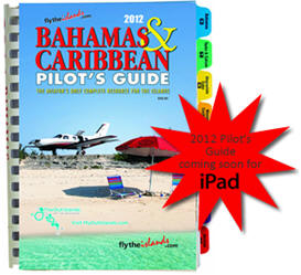
The 2012 Bahamas &
Caribbean Pilot's Guide Still The Best After 34 Years! By Jim Douglas |
||||
 |
November 6, 2011 - It's amazing, pilots still like to
have the beautifully printed Pilot's Guide in the
cockpit when travelling to the islands. Sure, having the
iPad app is great too, but there's nothing like flipping
through colorful pages as you fly over island after
island.
This 34th edition of The 2012 Bahamas & Caribbean
Pilot's Guide makes it easy to plan and execute a fun
and exciting flight to the islands. This edition has
newly designed island maps, hundreds of new photos, and
discovering what to do in the islands is easier than
ever.
The 2012 Bahamas & Caribbean Pilot's Guide, still the
only single-source reference for island travel, has all
the information you need, and it's all presented in a
colorful, beautiful book. Written primarily for pilots, this 400-page spiral bound Pilot's Guide is a great source of information for non-aviators too. With extensive accommodations and recreational information, this book is full of resources. |
|||
|
It is
conveniently organized into tabbed sections: the Bahamas, Turks
& Caicos, Hispaniola/Cuba (Dominican Republic, Haiti), Western
Caribbean (Cayman Islands, Jamaica, Yucatan, Belize, Roatan),
Puerto Rico/Virgin Islands, Eastern Caribbean (Anguilla south to
Aruba, Bonaire and Curacao), United States (Florida airports
with Customs) and Survival. Within each section there is travel
information on the islands, accommodation and car rental
listings, pilot info, maps and airport information.
Included
are frequencies, runway details, hours, fuel availability, color
aerial photographs of every airport in the Bahamas and the
Caribbean, GPS designators as well as longs & lats - a necessity
to find some of the small airports that won't be in your GPS
database. The general information section covers customs, flight
plans, forms, procedures, and required equipment in great
detail.
You don't
have to spend hours on the web to glean bits and pieces of
information - it's all right here in one beautiful book with
nearly a thousand color photos! It's a must-have in the cockpit
as you fly through the islands. The Pilot's guide is organized
by islands from north to south. Have it on your lap as you fly
down through the islands and be able to identify airports by the
aerial photographs as you fly over them. The pictures are really
worth a thousand words.
This
edition of the Bahamas & Caribbean Pilot's Guide features newly
designed island maps of some of the Bahamas islands and Puerto
Rico, and an extended Haiti section for humanitarian aid pilots.
The new maps include major roads, hotels and resorts, more
cities and settlements than before, beaches, and points of
interest. |
||||
|
Because of mutual
cooperation between the FAA and the Islands of the Bahamas, the
procedures are straight-forward, forms are simple, and the fees are
minimal. Only two airports have towers (Nassau and Freeport), but there
are 21 airports of entry (AOE) from which you can begin your journey.
After you enter the Bahamas through an AOE, you are free to island hop
using a Cruising Permit.
There are now six
great out island FBOs in the Bahamas, a substantial increase from past
years. First-class FBOs are also popping up in the Caribbean islands,
making flying in that region more user-friendly, not only for jets, but
for general aviation as well.
Each year nearly
5,000 copies of the Bahamas & Caribbean Pilot's Guide are sold. Last
year over 600 copies went to fractional share jet companies to put in
each of their aircraft. The U.S. Coast Guard buys the Pilot's Guide for
navigation and the wealth of information included in one place. AOPA
uses the Pilot's Guide in their travel planning department. Customs &
Immigration officers use it as a phone book because of all the valuable
phone numbers. Island pilots wouldn't fly without a copy, and general
aviation pilots use it to dream, plan and fly to the islands.
Published annually
since 1979, the Bahamas & Caribbean Pilot's Guide is the only
comprehensive, complete airport facilities directory available for the
region. Also available are two color VFR WAC scale charts. One covers
the entire Bahamas and the Turks & Caicos, and the other is the entire
Caribbean from Puerto Rico to the islands off the coast of Venezuela.
The charts are
$8.95 each, of both for $16.00. In addition, they offer a Forms Kit for
$21.95 that includes multiple copies of the forms you need for the
Bahamas. You can also purchase a pad of NCR General Declaration forms
for $21.95. Each is designed to make your tit, to the islands a breeze.
The Pilot's Guide is available for $56.95 from Pilot Publishing, Inc.
(800) 521-2120 or (760) 775-1900 or check out their
website. The Pilot's Guide
and charts can also be purchased through many online aviation stores and
at over 90 pilot shops and FBOs across the country. Bahamas & Caribbean Pilot's Guide is a valuable resource to use along with the Pilot's Guide, as it is updated with fuel prices, pilot information and features every airport that is in the Guide. Log on and use the Google maps as an overview on what you will see on your flight. |
|
|
| blog comments powered by Disqus |
 |
| ?AvStop
Online Magazine
Contact
Us
Return To News
|
|
