|
|||||||||||||||||

|
|
|
|||
|
2ND Warmest Summer
On Record Texas Warmest Summer On Record By Shane Nolan |
||||
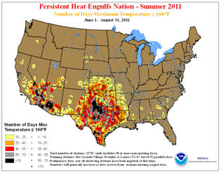 |
September 7, 2011 - The blistering heat experienced by the nation during August, as well as the June through August months, marks the second warmest summer on record according to scientists at NOAA’s National Climatic Data Center (NCDC) in Asheville, N.C.
The persistent heat, combined with below-average
precipitation across the southern U.S. during August and
the three summer months, continued a record-breaking
drought across the region.
The average U.S. temperature in August was 75.7 degrees
F, which is 3.0 degrees above the long-term (1901-2000)
average, while the summertime temperature was 74.5
degrees F, which is 2.4 degrees above average.
|
|||
|
Only nine
of the lower 48 states experienced August temperatures near
average, and no state had August average temperatures below
average. Wetter-than-normal conditions were widespread across
the Northeastern United States, which had its second wettest
August, as well as parts of the Northern Plains and California.
Drier-than-normal conditions reigned across the interior
West, the Midwest, and the South.
Hurricane
Irene made landfall near Cape Lookout, N.C. as a Category 1
storm on August 27, marking the first hurricane landfall in the
U.S. since Hurricane Ike in September 2008. Irene made a second
landfall in New Jersey as a hurricane on August 28, marking only
the second recorded hurricane landfall in that state.
Irene
contributed to New Jersey, New York, Vermont, and New Hampshire
having their wettest August on record. Meanwhile, Massachusetts
(2nd), Connecticut (2nd), Delaware (3rd), Maine (3rd), Maryland
(5th), Pennsylvania (5th), and Rhode Island (9th) had a top 10
wet August. |
||||
|
Several major U.S.
cities broke all-time monthly rainfall amounts during August. New York
City (Central Park) measured 18.95 inches of rain, exceeding the
previous record of 16.85 inches in 1882. In Philadelphia, 19.31 inches
of rain was observed, besting the previous monthly record of 13.07
inches in September 1999.
Louisiana (3rd),
Tennessee (4th), Texas (5th), Mississippi (6th), Georgia, (6th),
Illinois (8th), Washington (9th), and Alabama (9th) had precipitation
totals among their top ten driest on record.
Despite record
rainfall in parts of the country, drought covered about one-third of the
contiguous United States, according to the U.S. Drought Monitor. The
Palmer Hydrologic Drought Index indicated that parts of Louisiana, New
Mexico, Oklahoma and Texas are experiencing drought of greater
intensity, but not yet duration, than those of the 1930s and 1950s.
Drought intensity refers to the rate at which surface and ground water
is lost, due to a combination of several factors, including evaporation
and lack of precipitation.
An analysis of
Texas statewide tree-ring records dating back to 1550 indicates that the
summer 2011 drought in Texas is matched by only one summer (1789),
indicating that the summer 2011 drought appears to be unusual even in
the context of the multi-century tree-ring record.
Texas, Oklahoma,
New Mexico, and Louisiana had their warmest (June-August) summers on
record. Average summer temperatures in Texas and Oklahoma, at 86.8
degrees F and 86.5 degrees F, respectively, exceeded the previous
seasonal statewide average temperature record for any state during any
season. The previous warmest summer statewide average temperature was in
Oklahoma, during 1934 at 85.2 degrees F.
Fifteen states had
a summer average temperature ranking among their top ten warmest. West
of the Rockies, a persistent trough brought below-average temperatures
to the Pacific Northwest, where Washington and Oregon were the only
states across the lower 48 to have below-average summer temperatures.
Texas had its
driest summer on record, with a statewide average of 2.44 inches of
rain. This is 5.29 inches below the long-term average, and 1.04 inches
less than the previous driest summer in 1956. New Mexico had its second
driest summer and Oklahoma its third driest summer. New Jersey and
California had their wettest summers on record with 22.50 inches and
1.93 inches, respectively.
The U.S. Climate
Extremes Index, a measure of the percent area of the country
experiencing extreme climate conditions, was nearly four times the
average value was during summer 2011. This is the third largest summer
value of the record, which dates to 1910. The major drivers were
extremes in warm minimum and maximum temperatures and in the wet and dry
tails of the Palmer Drought Severity Index.
Based on NOAA's
Residential Energy Demand Temperature Index, the contiguous U.S.
temperature-related energy demand was 22.3 percent above average during
summer. This is the largest such value during the index’s period of
record, which dates to 1895.
During the
six-month period (March-August), much-above-average temperatures
dominated the southern and eastern United States. New Mexico, Oklahoma,
Texas, Louisiana, South Carolina, and Florida, all experienced their
warmest March-August on record. Cooler-than-average temperatures
dominated the West and Northwest.
For the
year-to-date period, the average statewide temperature for Texas was
69.9 degrees F, the warmest such period on record for the state. This
bests the previous record for the year-to-date period of 69.8 degrees F
in 2000.
For precipitation
year-to-date, New Mexico, Texas, and Louisiana have all had their driest
January-August periods on record, while Ohio, Pennsylvania, New York,
New Jersey, and Connecticut were record wet during the same period. |
|
|
 |
| ©AvStop
Online Magazine
Contact
Us
Return To News
|
|
