THE AVIATION WEATHER SERVICE PROGRAM
Providing weather service to aviation is a joint effort of the National Weather Service (NWS), the Federal Aviation Administration (FAA), the Department of Defense (DOD), and other aviation oriented groups and individuals. This section discusses the civilian agencies of the federal government and their services to the aviation community.
NATIONAL OCEANIC AND ATMOSPHERIC ADMINISTRATION (NOAA)
The National Oceanic and Atmospheric Administration (NOAA) is an agency of the Department of Commerce. NOAA is one of the leading scientific agencies in the U.S. government. Among its six major divisions are the National Environmental Satellite Data and Information Service (NESDIS) and the NWS.
NATIONAL ENVIRONMENTAL SATELLITE DATA AND INFORMATION SERVICE (NESDIS)
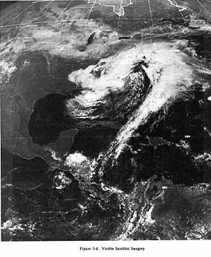
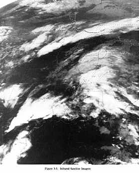
The National Environmental Satellite Data and Information Service (NESDIS) is located Washington, D.C. NESDIS directs the weather satellite program. Some NESDIS personnel work in close cooperation with NWS meteorologists at the National Meteorological Center (NMC) Satellite Field Distribution Facility (SFDF). Figures 3-4 and 3-5 are examples of Geostationary Operational Environmental Satellite (GOES) images, and Figures 3-6 and 3-7 are examples of NOAA Polar Orbiting Satellite images received from a SFDF. Satellite cloud images are available at field offices via the Satellite Weather Information System (SWIS) or a "GOES Tap" phone line.
NATIONAL WEATHER SERVICE (NWS)
The National Weather Service collects and analyzes meteorological and hydrological data, and subsequently prepares forecasts on a national, hemispheric, and global scale. The following is a description of the NWS facilities tasked with these duties.
National Meteorological Center (NMC)
The National Meteorological Center (NMC), located in Washington D.C., is the focal point of the NWS's weather processing system. From worldwide weather reports, NMC prepares weather analysis charts and guidance forecasts for use by NWS offices and other users. A few charts and forecasts are still manually prepared by meteorologists, but the majority are computer generated.
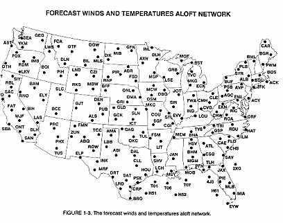
Some NMC products are specifically prepared for aviation. For example, the Winds and Temperatures Aloft Forecast. Figure 1-3 is the network of forecast winds and temperatures aloft for the contiguous 48 states. Figure 1-3A shows the Alaskan and Hawaiian network.
National Severe Storms Forecast Center (NSSFC)
The National Severe Storms Forecast Center (NSSFC) prepares and issues convective outlooks and forecasts, in addition to severe weather watches, for the conterminous 48 states. NSSFC is located in Kansas City, MO, near the heart of the area most frequently affected by severe thunderstorms.
National Hurricane Center (NHC)
The National Hurricane Center (NHC), located in Miami, FL, issues Hurricane Advisories for the Atlantic, the Caribbean, the Gulf of Mexico, the eastern Pacific, and adjacent land areas. The center also develops hurricane forecasting techniques and does hurricane research. The Central Pacific Hurricane Center in Honolulu issues Advisories for the central Pacific Ocean.
National Aviation Weather Advisory Unit (NAWAU)
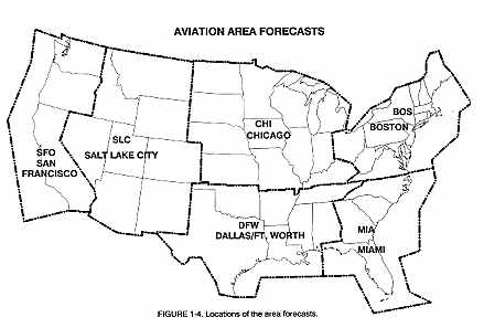
The National Aviation Weather Advisory Unit, located in Kansas City, MO, is dedicated to aviation. Meteorologists in this unit prepare and issue aviation Area Forecasts (FA) and In-Flight Weather Advisories [Airman's Meteorological Information (AIRMET), and Significant Meteorological Information (SIGMET) and Convective SIGMETs] for the contiguous 48 states (Figure 1-4)].
Weather Service Forecast Office (WSFO)
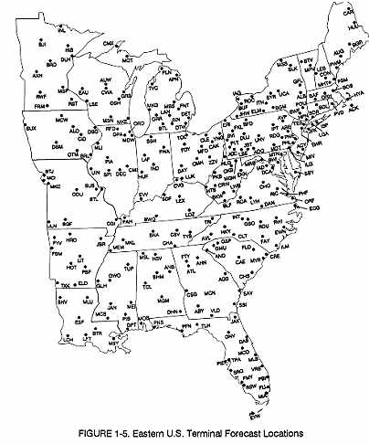
A Weather Service Forecast Office (WSFO) issues various public and aviation forecasts and weather warnings for their area of responsibility. In support of aviation, the forecasts include: Terminal Forecasts, as well as the forecasts used in the Transcribed Weather Broadcast (TWEB). The WSFOs in Alaska and Hawaii issue aviation Area Forecasts and In-Flight Advisories (AIRMETS, and international SIGMETS).
Figure 1-5 show locations for which Terminal Forecasts are issued. Figure 1-6 shows the TWEB routes.
Selected WSFOs also provide formal pilot weather briefings. Flight plan filing and NOTAM services are not available at NWS offices. Pilots can still receive specifically requested weather information from those WSFOs that do not offer formal briefings.
A Weather Service Office (WSO) prepares and issues public forecasts and weather warnings and provides general weather service for their local areas. Some WSOs provide formal pilot weather briefings, but the majority of them do not. Pilots can still receive specifically requested weather information from those offices that do not offer formal briefings.
The National Weather Service is currently undergoing a major Modernization and Associated Restructuring (MAR) in which the present field offices will be realigned into a new type of office. This office will be known as a Weather Forecast Office (WFO). These new offices will replace the present WSFO/WSO concept and will be designed to take advantage of WSR-88D Doppler Radar and other new technology to improve weather services. The WFOs will be staffed primarily with meteorologists and serve smaller areas than current WSFOs do. The second stage of the MAR is expected to be completed by the late 1990s.
FEDERAL AVIATION ADMINISTRATION (FAA)
The Federal Aviation Administration is a part of the Department of Transportation. The FAA provides a wide range of services to the aviation community. The following is a description of those FAA facilities which are involved with aviation weather and pilot services.
The FAA is in the process of modernizing its Flight Service Station program with two types of Flight Service Stations (FSSs). The first type is the older, manual (or non-automated) FSS which is the process of being consolidated into the second, newer, Automated FSS (AFSS). With about one per state and with lines of communications radiating out from it, these new AFSSs are referred to as "hub" facilities. Pilot services provided previously by the older FSSs have been consolidated into facilities with new technology to improve Pilot Weather Briefing services.
The FAA Flight Service Station (FSS or AFSS) provides more aviation weather briefing service than any other government service outlet. The FSS or AFSS provides preflight and inflight briefings, transcribed weather briefings, scheduled and unscheduled weather broadcasts, and furnishes weather support to flights in its area.
As a starting point for a preflight weather briefing, a pilot may wish to listen to one of the following three recorded weather briefings a FSS or AFSS can provide. For a more detailed briefing pilots can contact the FSS or AFSS directly.
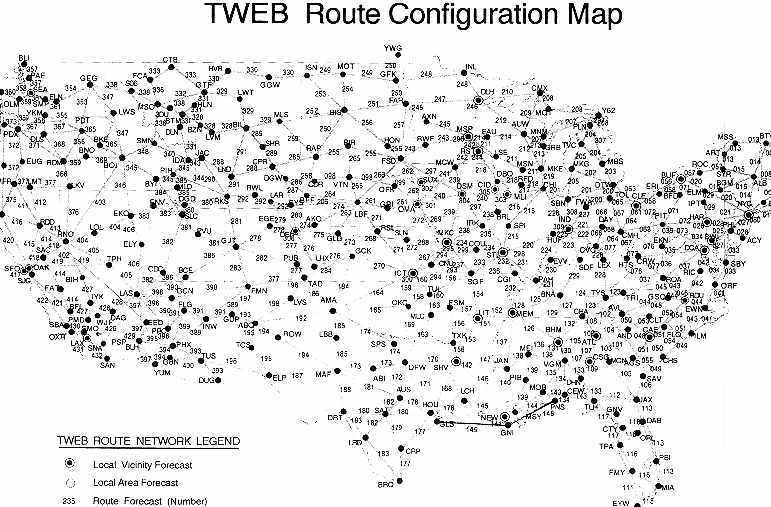
Transcribed Weather Broadcast (TWEB)
The Transcribed Weather Broadcast (TWEB) is a continuous broadcast on selected low/medium frequency navigation facilities (190 to 535 kHz) and VORs (108.0 to 117.95 MHz). The TWEB is based on a route-of-flight concept with the order and content of the TWEB transcription as follows:
1. Introduction
2. Synopsis
3. Adverse Conditions
4. TWEB Route Forecasts
5. Outlook (Optional)
6. Winds Aloft
7. Radar Reports
8. Aviation Weather Observations
9. Pilot Reports (PIREP)
10. Notices to Airmen (NOTAMs)
11. Military Training Activity
12. Density Altitude
13. Closing Announcement
Items 2, 3, 4, 5, and 6 are Forecasts and Advisories prepared by the NWS and are discussed in detail in Section 4. The Synopsis and Route Forecasts are prepared specifically for the TWEB by WSFOs. Adverse conditions, outlooks, and winds/temperature aloft are adapted from In-Flight Advisories, Area Forecasts, and the NMC Winds/Temperature Aloft Forecasts. Radar reports and pilot reports are discussed in Section 3. Surface reports are discussed in Section 2. Figure 1-6 shows TWEB routes for which forecasts are prepared.
Pilot's Automatic Telephone Weather Answering System (PATWAS)
Pilot's Automatic Telephone Weather Answering System (PATWAS) is a recorded telephone briefing service done by some manual FSSs with the forecast for the local area, usually within a 50 nautical mile radius of the station. A few selected stations also include Route Forecasts similar to the TWEB.
The order and content of the PATWAS recording is as follows:
1. Introduction (describing PATWAS area)
2. Adverse Conditions
3. Recommendation (VFR flight not recommended, if appropriate)
4. Synopsis
5. Current Conditions
6. Surface Winds
7. Forecast
8. Winds Aloft
9. NOTAMs
10. Military Training Activity
11. Request for PIREPs
12. Alert Notices (ALNOT), if applicable
13. Closing Announcements
14. Suspension Announcement
FAA facilities providing PATWAS have operational procedures that place a high operational priority on PATWAS. This ensures the information is current and accurate. Detailed PATWAS information is usually prepared at selected time intervals between 0500 and 2200 local time with updates issued as needed. A general outlook for the PATWAS area is available between 2200 and 0500 local time if service is reduced during the period. The Airport Facility Directory lists PATWAS telephone numbers for FSS briefing offices.
Transcribed Information Briefing Service (TIBS)
Transcribed Information Briefing Service (TIBS) is provided by AFSSs and provides continuous telephone recordings of meteorological and/or aeronautical information. Specifically, TIBS provides area and/or route briefings, airspace procedures, and special announcements, if applicable, concerning aviation interests.
Depending on user demand, other items provided may include Aviation Weather Observations, Terminal Forecasts, and Winds/Temperatures Aloft Forecasts. A general outlook for the TIBS is available between 2200 and 0500 local time if service is reduced during the period. The Airport Facility Directory lists TIBS telephone numbers for AFSS briefing offices. A touchtone telephone is necessary to access the TIBS program.
For those pilots already in flight and needing weather information and assistance, the following services are provided by flight service stations. They can be accessed over the proper radio frequencies printed, in flight information publications.
Hazardous Inflight Weather Advisory Service (HIWAS)
The Hazardous Inflight Weather Advisory Service (HIWAS) is a continuous broadcast service over selected VORs of In-Flight Weather Advisories; i.e. SIGMETs, CONVECTIVE SIGMETs, AIRMETs, Severe Weather Forecast Alerts (AWW), and Center Weather Advisories (CWA). [See Section 4 for a description of CWAs]. In areas where HIWAS is already being utilized, controllers and specialists have discontinued their routine broadcast of In-Flight Advisories, but continue to broadcast a short alerting message.
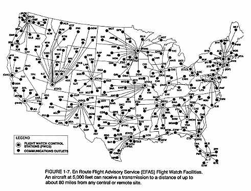
En Route flight Advisory Service (EFAS)
The En Route Flight Advisory Service (EFAS), or "Flight Watch," is a weather service on a common frequency (122.0 mHz), and on discrete frequencies at flight levels above 18,000 feet, from selected FSSs or AFSSs. The Flight Watch specialist provides aviation weather information, time-critical assistance to en route pilots facing hazardous or unknown weather conditions, and may recommend alternate or diversionary routes. Additionally, Flight Watch is a focal point for rapid receipt and dissemination of pilot reports. Figure 1-7 indicates the sites where EFAS and associated outlets are located. To use this service, call "FLIGHT WATCH." Example, "(Oakland) FLIGHT WATCH, THIS IS ..."
The following paragraphs describe other FAA facilities which provide support to the aviation community.
Air Traffic Control System Command Center (ATCSCC)
The Air Traffic Control Command Center (ATCCC) is located in the Washington, D.C. area with the objective of managing the flow of air traffic on a system-wide basis. The purpose is to minimize air traffic delays by watching capacity and demand, thereby achieving maximum utilization of the airspace.
Because weather is the most common reason for air traffic delays and reroutings, the ATCCC is supported full-time by NWS meteorologists in the Central Flow Weather Service Unit (CFWSU) located in the Central Flow Control Facility (CFCF). These NWS meteorologists monitor the weather throughout the Air Traffic System and anticipate weather developments that might affect system operations on the national level.
Air Route Traffic Control Center (ARTCC)
An Air Route Traffic Control Center (ARTCC) is an en route radar facility established to provide air traffic control service to aircraft operating on IFR flight plans within controlled airspace and principally during the en route phase of flight. When equipment capabilities and controller workload permit, certain advisory/assistance services may be provided to VFR aircraft.
Center Weather Service Unit (CWSU)
The purpose of the Center Weather Service Units (CWSU) are to provide weather consultation and advice to managers and staff within ARTCCs and to other supported FAA facilities. The CWSU is a joint agency aviation weather support team located at each ARTCC. The unit is composed of NWS meteorologists and FAA traffic management personnel, the latter being assigned as Weather Coordinators. The CWSU meteorologist provides FAA traffic managers with accurate and timely weather information. This information is based on monitoring, analysis, and interpretation of real-time weather data at the ARTCC through the use of all available data sources including radar, satellite, PIREPs, and various NWS products such as Terminal and Area Forecasts, In-Flight Advisories, etc. The flow or exchange of weather information between the CWSU meteorologists and the FAA personnel in the ARTCC is the responsibility of the Weather Coordinator.
Similar to the CWSUs in the ARTCCs, there is a Central Flow Weather Service Unit (CFWSU) located in the Central Flow Control Facility (CFCF) in the ATCSCC. The on-duty meteorologist in the CFWSU has the responsibility of weather coordination on the national level.
Air Traffic Control Tower (ATCT)
The FAA Terminal Controller informs arriving and departing aircraft of pertinent local weather conditions. The controller becomes familiar with and remains aware of current weather information needed to perform air traffic control duties in the vicinity of the terminal. The responsibility for reporting visibility observations is shared with the NWS at many ATCT facilities. At other tower facilities, the controller has the full responsibility for observing, reporting and classifying aviation weather elements.
Automatic Terminal Information Service (ATIS) is provided at most major airports to inform pilots, as they approach the terminal area, of the current weather and other pertinent local airport information.
Direct User Access Terminal Service (DUATS)
Direct User Access Terminal System (DUATS) is an FAA operated information system which enables pilots and other aviation interests to conduct their own weather briefings. The computer-based system receives and stores a number of NWS and FAA products which are commonly used in pilot weather briefings. Pilots using a personal computer and modem can access the system and request weather and other pertinent data for planned flights. The pilot can also file and amend flight plans while dialed into the system. Further information about DUATS can be obtained from any AFSS or FAA Flight Standards District Office (FSDO).
AM WEATHER is a fifteen-minute weather program aired Monday through Friday mornings over more than 300 Public Broadcast Television Stations.
Professional meteorologists from the NWS and NESDIS provide weather information primarily for pilots enabling them to make better "go or no-go" flight decisions.
National and Regional Weather Maps along with satellite sequences, Radar Reports, Winds/Temperature Aloft Forecasts, AWWs, and In-Flight Weather Advisories. Extended Forecasts are provided Monday through Friday. Friday's forecast covers the weekend. AM WEATHER also serves many other interest groups that depend upon weather information.
AM WEATHER utilizes the U.S. weather observation network, GOES and NOAA Polar Orbiting satellite data, and computer analysis to produce daily aviation outlooks.
For Alaskan aviation weather interests, a meteorologist from WSFO Anchorage conducts a 30-minute program, Monday through Friday, on Alaska's Public Television. This broadcast airs at 6 PM local time throughout the state.
OBSERVATIONS
Weather observations are measurements and estimates of existing weather
conditions both at the surface and aloft. When recorded and transmitted,
an observation becomes a report and reports are the basis of all weather
analyses, forecasts, advisories, and briefings. The following paragraphs
briefly describe the observation programs of the NWS and the FAA. More
detailed information on each program can be found in the following sections.
Surface Aviation Weather Observations
Surface Aviation Weather Observations include weather elements pertinent to flying. A network of airport stations provides routine up-to-date surface weather information. Most of the stations in the network are either NWS or FAA; however, the military services and contracted civilians are also included. Automated Surface Observing Systems (ASOS), Automated Weather Observing System (AWOS), and other automated weather observing systems are becoming a major part of the surface weather observing network. For more information on surface aviation observations, see Section 2.
Upper air weather data is received from sounding balloons (known as radiosonde observations) and PIREPs. Upper air observations are taken twice daily at specified stations. These upper air observations furnish temperature, humidity, pressure, and wind data, often to heights above 100,000 feet. In addition, pilots are a vital source of upper air weather observations. In fact, aircraft in flight are the only means of directly observing turbulence, icing, and height of cloud tops. For more information on PIREPS, see Section 3.
A new sensing system utilizing vertically oriented radars will provide increased real-time data from the upper atmosphere. These radars will provide wind profiles of the atmosphere; hence, the system is known as the Profiler Network. At present, upper-level winds are the only data obtained from the network, but in time other parameters such as temperature and moisture content at various levels may be available. A limited network of profilers is being tested in the central part of the country. Nationwide deployment is expected in the near future.
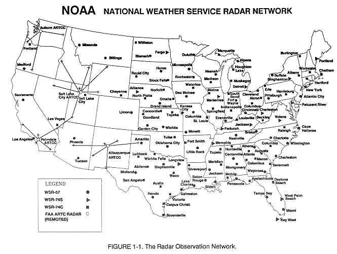
Precipitation reflects radar signals and the reflected signals are displayed as echoes on the radar scope. NWS radar covers all the United States east of the Rocky Mountains with radar coverage over the remainder of the U.S. largely by ARTCC radars. Except for some western mountainous terrain, radar coverage is nearly complete over the contiguous 48 states. Figure 1-1 shows the radar observation network.
A Radar Remote Weather Display System (RRWDS) is specifically designed system to provide real-time radar weather information from many different radars. The RRWDS display is similar to the color video display systems. RRWDS is connected to FAA and Air Force Air Route Surveillance radars as well as NWS weather radars. The system gives briefers access to real-time radar weather information across the entire country.
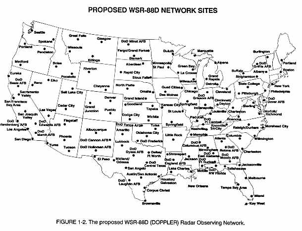
A new radar system, the WSR-88D, is being installed across the United States and is a joint effort of the NWS, FAA and DOD. These radars use Doppler technology which provides greater detail and enhanced information about thunderstorms and weather systems in support of public and aviation warning and forecast programs. Figure 1-2 shows the proposed WSR-88D observing network. As the Doppler radars are commissioned, the older conventional weather radars will be decommissioned.
An FAA Doppler radar, Terminal Doppler Weather Radar (TDWR), is being installed near a number of major airports around the country. The TDWR will be specifically used to alert and warn airport controllers of approaching wind shear, gust fronts, and heavy precipitation which could cause hazardous conditions for landing or departing aircraft.
Also installed at 45 major airports is the FAA airport surveillance radar, ASR-9. With the ASR-9, specific locations of six different precipitation intensity levels will be available for the safe routing of air traffic in and about a terminal location.
Low Level Wind Shear Alert System (LLWAS)
The Low Level Wind Shear Alert System (LLWAS) provides pilots and controllers with information on hazardous surface wind conditions (on or near the airport) that creates unsafe landing or departure conditions. LLWAS evaluates wind speed and direction from sensors on the airport periphery with center field wind data. During the time that an alert is posted, air traffic controllers provide Wind Shear Advisories to all arriving and departing aircraft.
Visible and infrared imagery (or pictures) of clouds are taken from weather satellites in orbit. The pictures are then made available on a near real time basis to NWS and FAA facilities. Satellite pictures are an important source of weather information. For more information on satellite products, see Section 3, "Satellite Weather Pictures."
COMMUNICATION SYSTEMS
High speed communications and automated data processing have improved the flow of weather data and products through the nation's weather network. The flow of weather information within and between agencies is becoming faster as computers and satellites are being used to facilitate the exchange of data. A new computer-based Advanced Weather Interactive Processing System (AWIPS) is being developed for the National Weather Service. This system will replace the current system and will allow quicker dissemination of weather information between NWS offices and NWS offices and their users. This system will be linked with the WSR-88D system to provide better detection, observing, and forecasting of weather systems, especially severe weather. The AWIPS network is scheduled to be in place in NWS offices by the late 1990s.
The flow of alphanumeric weather information to the FAA Service Outlets is accomplished through leased lines to computer based equipment. The NWS and FAA Service Outlets exchange weather information through the use of graphic products and alphanumeric information. Graphic products (weather maps) are received by FAA Service Outlets from NMC through a private sector contractor. Alphanumeric information exchanged through telecommunication gateways at NWS and FAA switching centers serves to pass data between the various FAA facilities, NWS, and other users.
USERS
The ultimate users of the aviation weather service are pilots and dispatchers. Maintenance personnel may use the service to keep informed of weather that could cause possible damage to unprotected aircraft. Pilots contribute to, as well as use, the service. Pilots should send PIREPs to help fellow pilots, briefers and forecasters. The service can be no better or more complete than the information that goes into it.
In the interest of safety and in compliance with Federal Aviation Regulations, all pilots should get a complete weather briefing before each flight. It is responsibility of the pilot to ensure he/she has all the information needed to make a safe flight.
Obtaining a Good Weather Briefing
When requesting a briefing, pilots should identify themselves as pilots and give clear and concise facts about their flight:
1. Type of flight VFR or IFR
2. Aircraft number or pilot's name
3. Aircraft type
4. Departure point
5. Route-of-flight
6. Destination
7. Flight altitude(s)
8. Estimated time of departure
9. Estimated time en route or estimated time of arrival
With this background, the briefer can proceed directly with the briefing and concentrate on weather relevant to the flight.
The weather information received depends on the type of briefing requested. A STANDARD briefing should include:
1. Adverse conditions (pilots may elect to cancel at this point)
2. VFR flight not recommended [FSS/AFSS briefers only]
3. Weather synopsis (positions and movements of lows, highs, fronts
and other significant causes of weather)
4. Current weather
5. Forecast weather (en route and destination)
6. Forecast winds/temperatures aloft
7. Alternate routes (if any)
8. Aeronautical information (NOTAMs)
9. ATC delays
10. Request for PIREPs
An ABBREVIATED briefing will be provided at the user's request (1) to supplement mass disseminated data, (2) to update a previous briefing, or (3) to request specific information only.
An OUTLOOK briefing will be provided when the briefing is six or more hours in advance of the proposed departure. Briefing will be limited to applicable forecast data for the proposed flight.
The FSS/AFSS's purpose is to serve the aviation community. Pilots should
not hesitate to ask questions and discuss factors they do not fully understand.
The briefing should be considered complete only when the pilot has a clear
picture of what weather to expect. It is also advantageous for the pilot
to make a final weather check immediately before departure if at all possible.