|
|||||||||||||||||

|
|
|
|||
|
National Weather
Services' Satellite Broadcast Network Bandwidth Tripled By Shane Nolan |
||||
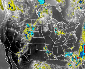 |
July 1, 2011 - Enhancing forecasters' access to data and imagery
from an array of sensors and satellites, Raytheon’s Advanced
Weather Interactive Processing System team has successfully
tripled the bandwidth on the Satellite Broadcast Network
(SBN)/NOAAPort, the primary vehicle through which
hydrometeorological forecasting products are provided to the
National Weather Service's Advanced Weather Interactive
Processing System (AWIPS).
Serving more than 130 weather forecast offices and river
forecast centers, the SBN expansion is critical to the
performance of AWIPS, which gives forecasters access to data
and imagery from an array of weather sensors and satellites
through interactive workstations. AWIPS provides complex
analysis and data integration for more than 130 weather
forecast offices and river forecast centers across the
nation. |
|||
|
"Communications provides data—the lifeblood of NWS
operations; and with the SBN expansion, forecasters using
AWIPS will have access to more precise data than ever, which
is critical for improving forecasts and warnings, and saving
lives," said Don Berchoff, director of NWS Office of Science
and Technology."
"Tripling the SBN bandwidth will also benefit forecasts,
warnings and other products for the mass media, emergency
management agencies and private weather services," said Todd
Probert, vice president and chief operating officer of
Mission Operations Solutions for Raytheon Intelligence and
Information Systems. "The SBN expansion is part of the
Raytheon AWIPS team's commitment to going beyond just simply
meeting program objectives by providing superior technical
solutions to help the National Weather Service achieve
mission success."
The
driving force of the bandwidth expansion and hardware
upgrade is to support the dissemination of additional data
products over the SBN/NOAAPort such as dual polarization
radar products, GOES and POES satellite products, and
analysis and forecast products.
In
addition to the expansion, the team also transitioned the
SBN to a Digital Video Broadcasting–Satellite–Second
Generation service, and provided for the incorporation of
NOAA Weather Wire Service broadcasts into the SBN as part of
the Weather Radio Improvement Program. |
||||
