|
|||||||||||||||||

|
|
|
|||
|
ITT Launches New
Flight Tracking Application For Alaskan Airspace By Jim Douglas |
||||
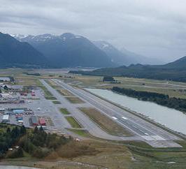 |
October 5, 2011 - ITT has launched a Web-based data
visualization application that enhances the safety and
operational efficiency of Alaskan airspace by providing
unprecedented fleet awareness.
ITT’s AlaskaVue provides a cost-effective solution for
understanding in real time where flight assets are
located. This capability is particularly significant for
Alaska, where weather, terrain and gaps in radar
coverage can affect situational awareness and contribute
to accident rates that are much higher than in the
continental United States. “Alaskan airspace has undergone a dramatic transformation in recent years. It began with the success of the Alaska Capstone Project, which laid the groundwork for implementing the Federal Aviation Administration’s (FAA) Next Generation Air Transportation System (NextGen) initiative,” said John Kefaliotis, ITT’s vice president of next generation transportation systems. |
|||
|
The
Capstone Program is an FAA funded safety program located in
Alaska, primarily focusing on rural areas of the state. The
program concentrates on increasing safety in aviation through
technology and making the process of integrating that technology
more efficient. Some of the systems currently being developed in
Capstone includes GPS Receivers, Data Link Transceivers, ADS-B,
Multi-Function Displays, Flight Information Services, Moving
Maps, and Terrain Databases.
“ITT
continually looks for ways to support airspace safety and
efficiency; the launch of AlaskaVue provides real-time flight
tracking and historical playback to improve flight safety in
Alaska.”
The
AlaskaVue application service has pan and zoom capabilities;
multiple views, such as satellite, maps, charts and elevation;
multiple overlays, such as significant boundaries, runways, air
routes and navigation aids; flexible display options; and color
coding of flight objects. AlaskaVue includes saved views and
historical playback. Subscribers to AlaskaVue will access the
data visualization application and the comprehensive
surveillance data via the Internet. AlaskaVue is based on a synthesis of multiple FAA system-derived aircraft surveillance data available in the U.S. National Airspace System. AlaskaVue data sources include data derived from the U.S. Automatic Dependent Surveillance-Broadcast (ADS-B) network being deployed by ITT, along with Wide Area Multilateration (WAM) data from FAA-deployed WAM systems. |
||||