|
|||||||||||||||||

|
|
|
|||
|
NASA, Japan Release
Improved Topographic Map Of Earth By Jim Douglas |
||||
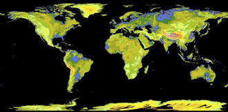 |
October 19, 2011 - NASA and Japan released a
significantly improved version of the most complete
digital topographic map of Earth on Monday, produced
with detailed measurements from NASA's Terra spacecraft.
The map, known as a global digital elevation model, was created from images collected by the Japanese Advanced Spaceborne Thermal Emission and Reflection Radiometer, or ASTER, instrument aboard Terra. So-called stereo-pair images are produced by merging two slightly offset two-dimensional images to create the three-dimensional effect of depth. |
|||
|
The first
version of the map was released by NASA and Japan's Ministry of
Economy, Trade and Industry (METI) in June 2009. "The ASTER
global digital elevation model was already the most complete,
consistent global topographic map in the world," said Woody
Turner, ASTER program scientist at NASA Headquarters in
Washington. "With these enhancements, its resolution is in many
respects comparable to the U.S. data from NASA's Shuttle Radar
Topography Mission (SRTM), while covering more of the globe."
The
improved version of the map adds 260,000 additional stereo-pair
images to improve coverage. It features improved spatial
resolution, increased horizontal and vertical accuracy, more
realistic coverage over water bodies and the ability to identify
lakes as small as 0.6 miles (1 kilometer) in diameter.
"This
updated version of the ASTER global digital elevation model
provides civilian users with the highest-resolution global
topography data available," said Mike Abrams, ASTER science team
leader at NASA's Jet Propulsion Laboratory in Pasadena, Calif.
"These data can be used for a broad range of applications, from
planning highways and protecting lands with cultural or
environmental significance, to searching for natural resources."
The ASTER
data cover 99 percent of Earth's landmass and span from 83
degrees north latitude to 83 degrees south. Each elevation
measurement point in the data is 98 feet (30 meters) apart.
NASA and METI are jointly contributing the data for the ASTER topographic map to the Group on Earth Observations, an international partnership headquartered at the World Meteorological Organization in Geneva, Switzerland, for use in its Global Earth Observation System of Systems. This "system of systems" is a collaborative, international effort to share and integrate Earth observation data from many different instruments and systems to help monitor and forecast global environmental changes. |
||||