FAA Roll Out Of Airport Surface Detection Equipment (ASDE-X) At 35 Airports


NEWSROOM
 
 
  Bookmark and Share


FAA Roll Out Of Airport Surface Detection Equipment (ASDE-X) At 35 Airports

By Mike Mitchell
 

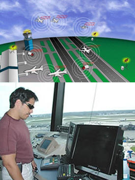
October 6, 2011 - Memphis is the 35th airport to commission ASDE-X, which greatly reduces the potential for collisions on airport runways and taxiways by allowing air traffic controllers to detect potential conflicts and take appropriate action. 

Airport Surface Detection Equipment, Model X, or ASDE-X, is a runway-safety tool that enables air traffic controllers to detect potential runway conflicts by providing detailed coverage of movement on runways and taxiways.

By collecting data from a variety of sources, ASDE-X is able to track vehicles and aircraft on airport surfaces and obtain identification information from aircraft transponders. 

ASDE-X works by monitoring real-time surface activity taken from a variety of sources, including radar, sensors from the satellite-based surveillance system called Automatic Dependent Surveillance ? Broadcast, multilateration sensors and aircraft transponders.  

ASDE-X fuses this data and projects them on color displays that allow controllers to see the precise location of aircraft and transponder-equipped vehicles on runways, taxiways and approach corridors, as well as aircraft flying within five miles of the airport. The transponders provide the identity of each aircraft and vehicle.

ASDE-X is especially helpful to controllers at night or in bad weather when visibility is poor. An enhanced safety logic spots potential collisions and provides visual and audible alerts to controllers. Originally the FAA installed 38 ASDE-3A radar systems at the nation's busiest airports. The cost-effective alternative to the ASDE-3/AMASS capability, referred to as ASDE-X, is one of the first new runway safety program technologies aimed at improving ATCS situational awareness by providing tools to supplement their tasks (McAnulty, Doros, & Poston, 2001).  

The data that ASDE-X uses comes from a surface movement radar located on the air traffic control tower or remote tower, multilateration sensors, ADS-B (Automatic Dependent Surveillance-Broadcast) sensors, terminal radars, the terminal automation system, and from aircraft transponders. By fusing the data from these sources, ASDE-X is able to determine the position and identification of aircraft and vehicles on the airport surfaces, as well as of aircraft flying within 5 miles (8 km) of the airport (selectively up to 60 nmi). 


The first ASDE-X became operational at General Mitchell International Airport in Milwaukee in June 2003. Below is a list of the 35 airports with the system. 

Baltimore ? Washington International Airport
Boston Logan International Airport
Bradley International Airport
Chicago Midway Airport
Chicago O?Hare International Airport
Charlotte Douglas International Airport
Dallas ? Ft. Worth International Airport
Denver International Airport
Detroit Metro Wayne County Airport
Ft. Lauderdale/Hollywood Airport
General Mitchell International Airport
George Bush Intercontinental Airport
Hartsfield ? Jackson Atlanta International Airport
Honolulu International ? Hickam Air Force Base Airport
John F. Kennedy International Airport
John Wayne ? Orange County Airport

LaGuardia Airport
Lambert ? St. Louis International Airport
Las Vegas McCarran International Airport
Los Angeles International Airport
Louisville International Airport-Standiford Field
Memphis International Airport
Miami International Airport
Minneapolis St. Paul International Airport
Newark International Airport
Orlando International Airport
Philadelphia International Airport
Phoenix Sky Harbor International Airport
Ronald Reagan Washington National Airport
San Diego International Airport
Salt Lake City International Airport
Seattle-Tacoma International Airport
Theodore Francis Green State Airport
Washington Dulles International Airport 


Controllers in the tower see this information presented as a color display of aircraft and vehicle positions overlaid on a map of the airport's runways/taxiways and approach corridors. The system essentially creates a continuously updated map of all airport-surface operations that controllers can use to spot potential collisions.

Other News Stories (For the latest news please checkout our home page)


Home Aviation News Aviation Stories Of Interest FAA Exam Upcoming Events Links To Other Sites General Aviation Helicopters Medical Factors Facing Pilots
Maintenance and Aircraft Mechanics Hot Air Balloon Aviation Training Handbooks Read Online Aviation History Legal Issues In Aviation Sea Planes Editorials
 
 ?AvStop Online Magazine                                                                 Contact Us                                                  Return To News                                          Bookmark and Share


AvStop Aviation News and Resource Online Magazine

Grab this Headline Animator